
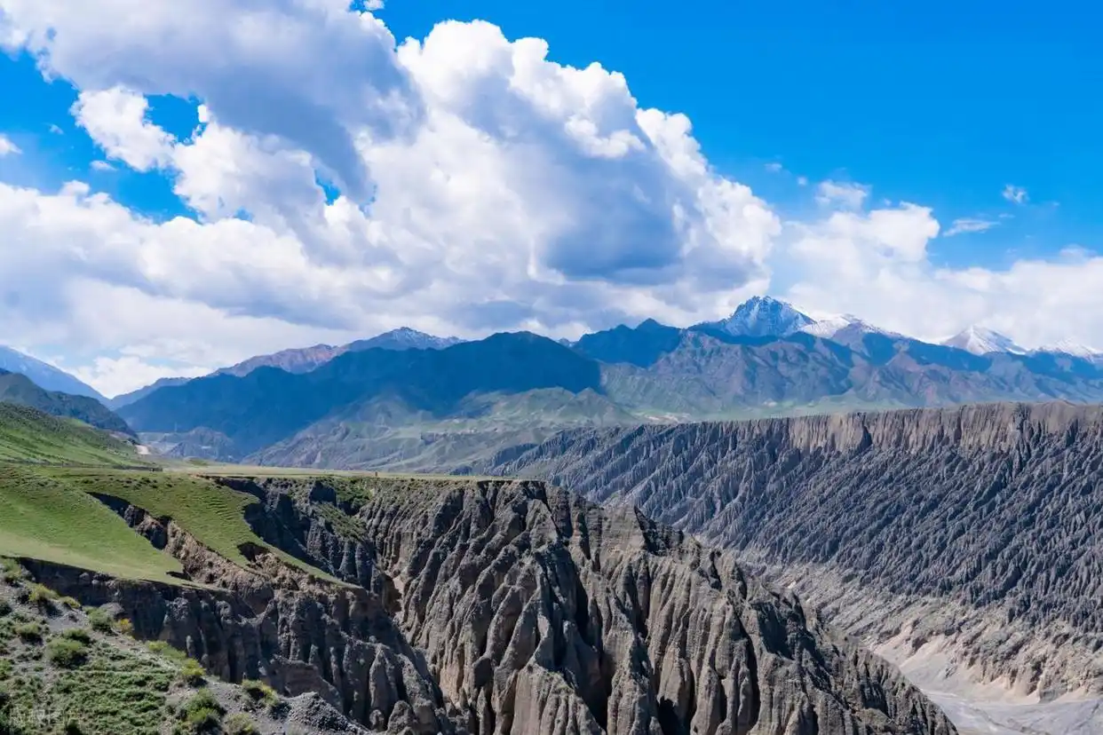
Jeminay and the Tuoputiereke Grand Canyon: a quiet Altay drive
I drove into Jeminay on a Tuesday in late September. The road from Burqin had flattened into a steady run of grey-brown steppe, and the wind was already working the door as I slowed for the county gate. Nobody warned me about the wind. Everyone mentions Kanas, the larch, the lake that turns turquoise in October. Nobody mentions that the western edge of Altay Prefecture is where the wind goes to practice. I had come for the Tuoputiereke Grand Canyon, a name most foreign drivers have never heard, and I was almost alone at the rim two hours later.
The drive west from Burqin
Burqin sits roughly 100 kilometres east of Jeminay by the provincial roads, though the number on your odometer depends on which way you cut it. I took the S227 north out of Burqin and then swung west on the county road, and the surface stayed good until the last 30 kilometres, where it turned to a washboard that rattled the roof box and loosened a bottle in the door pocket. Give yourself two and a half hours, not the 90 minutes the map promises. The map lies about wind and washboard, and it lies about both here.
I made one wrong turn at a junction where the sign pointed two ways with the same word, and I lost twenty minutes to a dead-end village before a man on a tractor waved me back. That is the kind of friction that makes a place feel real rather than packaged. The villages out here are spread thin, the fences are long, and the horizon is the only thing that moves fast. Drive it in daylight. The last stretch has no lights and the wind throws dust across the beam.
Fuel is the first real constraint. I filled in Burqin at ¥7.6 a litre and watched the gauge as the hills emptied out. There is a station at the Jeminay town entrance, but on a quiet weekday in spring it ran out of 92 octane by mid-afternoon, and the attendant just pointed at the empty pump. Carry a margin. The nearest reliable refill after that is back the way you came, and you do not want to be the driver walking into a border county asking where the petrol went. I now treat the Burqin fill as non-negotiable.
On the way you pass the northern shore of the fishing villages on Ulungur Lake, worth a slow pass if the light is right, though I kept moving because the canyon was closing its gate at dusk. The lake is enormous and flat and strange, a blue sheet dropped on the steppe, and the villages along it sell smoked fish from roadside racks for ¥20 a piece. Pull over once if you have the time. The water goes on longer than you expect, and the birds come down in the evening in numbers that make the drive worth a detour.
Jeminay town and the border-port feel
The town reads like a place that knows it is a frontier. There is a port here, the Jeminay land crossing into Kazakhstan, and you see the long fences and the parked freight before you see much else. Foreigners cannot simply walk up and cross. The crossing is for trade and organised passage, and the casual day-trip idea dies the moment you read the signs. I asked at a small hotel desk and got a shrug and a cup of tea, which is its own kind of answer. The tea was good. The crossing was not happening.
What the town does give you is a clean, quiet base at the edge of nowhere. Rooms run ¥150 to ¥260 in the shoulder season, cash is still welcome at the bazaar, and the night market stalls open late. I ate laghman that was fine and a kebab that was not, and watched the wind push paper across the square. The border atmosphere is real but undramatic: a few customs buildings, a lot of truck noise in the morning, and a deep quiet by ten. You feel the line without ever seeing it.
Standing at the Tuoputiereke rim
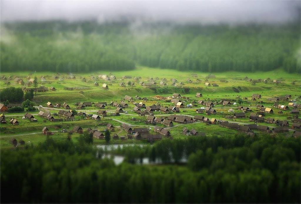
The geopark sits a short hop from town, and the road in is graded gravel with a gate that someone actually locks. I arrived to find it closed for an hour at lunch, which is the kind of friction that makes a place feel real rather than packaged. When it opened, a short boardwalk led to a rim where the ground simply fell away into a deep, dry gorge cut in stripes of red and ochre. I was the only person there. That sentence is the whole point of the drive, and it is the part nobody tells you about when they describe Altay.
The canyon is not a single chasm but a system, a set of layered cuts running into the arid hills. The boardwalk gives you three or four viewpoints, each one a different colour of rock, and a railing that keeps you honest near the edge. Below, the wind had smoothed the walls into shapes that locals compare to a devil city, though the comparison is looser here than at the famous badlands further south. Stand still for a minute and the only sound is the wind moving through the cut. Entry was a modest ticket when I went, around ¥30 to ¥45, and the gate hours bent with the season and the staff.
The geology is the quiet star. These hills are sedimentary, laid down in bands, and the erosion has sliced them clean so you can read the strata like a book someone left open. The red layers are iron-rich, the pale ones are ash and sand, and the whole thing sits at around 1,000 metres of altitude, low enough that the air stays warm well into October. I spent an hour at the second viewpoint just watching the light move across the bands. Nobody hurried me. Nobody was there to hurry me.
The wind-carved badlands
Jeminay is locally famous for its wind, and after an hour at the rim I understood why. It comes in steady, gritty pulses, the kind that loads your eyelashes with dust and your camera with grit. The badland section of the geopark shows what a few hundred years of that does to soft rock. The shapes are rounded, hollowed, almost architectural in places, and in the low autumn sun they throw long shadows that make the gorge look deeper than it measures on foot.
Bring a buff for your face and a cloth for the lens. I changed memory cards with the wind trying to take them, and I lost a cap to a gust I still think about. The rangers wear padded jackets in every season and they laughed when I asked if it ever stops. It does not, they said. Not really. Plan your photos for the calm ten-second windows and accept that most of your footage will sound like a furnace. The wind is not a backdrop here. It is the co-author of the place.
Summer heat versus September colour
I went in late September and the hills were dry gold with the first cold coming. Summer is a different animal. Temperatures push past 30 degrees by early afternoon, the light flattens, and the wind picks up dust that hangs in the air like a curtain. If you want colour, come after the first cold snap in October, when the small birch and the steppe grasses turn and the canyon reads warm against a hard blue sky. The trade is simple: summer gives you long days and open everything but little relief from heat and haze, while autumn gives you cold mornings, thin crowds, and the best light of the year.
What the two seasons actually feel like
In July I would have baked at the rim and squinted through the dust. In late September I wore a padded jacket at the morning gate and peeled it off by noon. The difference is not small. The canyon wants a low sun, and the low sun only comes with the short days of autumn. I would take a late-September morning over a July afternoon without a second thought, and I say that as someone who likes heat. The rock does the rest.
Fuel, cash, and the closed gate
The practical list is short and worth saying twice. Cash: bring it. The bazaar and the smaller stalls do not all take foreign cards, and the one ATM in town that worked for me rejected a second card an hour later with a screen I could not read. I pulled ¥500 from a county bank and that covered fuel, food, and the ticket with room to spare. Do not arrive expecting to tap your way through a border town. The machines here are choosy and the shops are honest but cash-first.
Fuel: fill before you leave Burqin or Habahe, and do not trust a weekday refill inside the county. I watched one pump run dry and another refuse a foreign card, and the ranger at the geopark just nodded when I described it. He had seen it. Food: the town has it, the geopark does not, so pack water and something solid before you drive out. The gate that closed at lunch is not a one-off. The park runs on a small staff and a thin season, and hours shift with the wind and the light.
I waited 55 minutes the first time and 20 the next. Build the wait into your day. If you arrive at four in the afternoon in autumn you may find the last boardwalk slot closing as you pay, and the rim in flat dusk is not the rim you came for. The staff are friendly and firm, and they will tell you plainly when the last walk is. Listen to them. The canyon is not going anywhere, and the wind will still be there tomorrow, exactly as strong, exactly as rude.
Camping and the geopark rules
I asked about camping near the rim and got a firm no, then a softer maybe if I stayed in the designated county area well back from the edge. The geopark protects the rock, and free camping on the cut is off the table. There is dispersed camping on the steppe outside town if you are self-sufficient, but the wind will test your pegs and your patience. I slept in town and drove out at first light, which gave me the canyon alone and the photographs before the gusts built. That early start was the best decision of the trip.
What the rangers will and will not allow
Rules are posted in a basic English line and the rangers mean them. Stay on the boardwalk, do not climb the cut, and do not fly a drone without asking. I asked. The answer was no, with a smile, and I understood. The place is quiet because it is still mostly left alone, and the easiest way to lose that is a dozen drones over the rim. Pack out what you bring. The bins at the gate are few and the wind scatters anything loose, so a closed bag in the car is the move. Leave the cut as you found it and it stays findable for the next driver.
Pairing Jeminay with the rest of Altay
Jeminay works best as the quiet western end of a longer Altay loop. From here you can run back east to the colourful beach at Burqin, that strange littered shore of weathered rock at the river mouth, and use Burqin as the jump point north to Kanas. Or swing south to the birch forest and white sand lake around Habahe County, where the trees turn the colour of flame in early October and the lake sits flat and white beside them.
If your loop comes from the south, hiking the granite canyon trails at Koktokay makes a natural partner, a different kind of gorge cut by water rather than wind, and the two together show you how varied this prefecture’s stone can be. And if you are arriving from the capital, the long desert expressway run north from Urumqi drops you into Altay fast, though I prefer the slower roads that let the steppe open up gradually and give the wind time to announce itself.
Jeminay will not be empty forever. For now it is a place where you can stand at a canyon rim with no one else in sight and hear only the wind that defines the county. That is worth the washboard and the closed gate. Drive it slow, fill up early, carry cash, and give the wind the respect it has earned. The Tuoputiereke Grand Canyon is the quiet alternative to the Kanas line, and the quiet is the whole point.