

The Xinjiang to Tibet Overland Route: Driving From Yecheng to the Plateau
The Xinjiang to Tibet Overland Route: Driving From Yecheng to the Plateau
There is a road that starts in a dusty Xinjiang county town and ends, two days later, on the roof of the world. The Xinjiang-Tibet Highway, marked G219, runs from Yecheng up across the Karakoram and Kunlun ranges to the Tibetan plateau. It is one of the most demanding drives on the planet, and also one of the most beautiful. I drove it northbound in a rented 4×4 with a week of supplies, and I would do it again tomorrow, but only because I respected what the road demands.
This is the planning guide for the crossing itself. For the detailed road conditions, the G219 Yecheng-to-plateau guide is the one to read before you turn the key. For the driving etiquette that keeps you alive around the truck traffic, the overtaking trucks guide is required reading.
Why Yecheng
Yecheng, also called Karghilik, is the last real town before the climb. Fuel up completely here, because the next petrol station with reliable supply is hundreds of kilometers away at altitude. Stock water, food, a sleeping bag rated below zero, and any medication. The town has basic hotels and a morning market where you can buy dried fruit and flatbread for the road.
From Yecheng the highway climbs hard. You gain more than 3,000 meters of elevation in the first stretch, and the air thins fast. We stopped at 3,000 meters for a night rather than pushing through, and that single decision is why nobody in the car got sick.
The high passes
The road crosses multiple passes above 4,500 meters, with the highest stretches near 5,000 meters. At that altitude the engine loses power, the walk to the toilet leaves you breathless, and the night temperature drops well below freezing even in summer. Go slow, drink constantly, and never let the fuel gauge drop below half, because a cold night stranded at 5,000 meters is a genuine emergency.
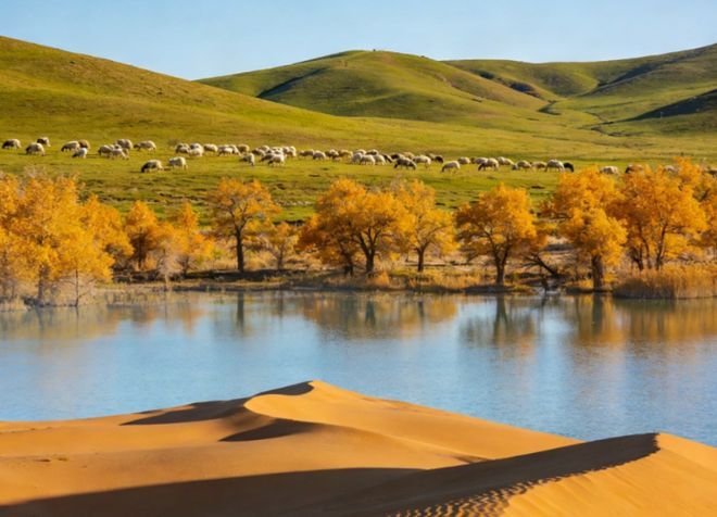
The views are absurd: black mountain walls, frozen lakes the color of slate, and a sky so close it feels painted. We pulled over at a nameless lake at 4,800 meters and sat for an hour. No other car passed. That is the gift of this road: solitude at the edge of what is drivable.
Connecting routes worth knowing
If a full Tibet crossing is too much, the Tarim Basin loop gives you desert highway drama without the altitude, circling the Taklamakan on two different roads. And the G315 Qinghai-Xinjiang highway offers a gentler east-west crossing through the Qaidam basin if you want plateau scenery at a lower cost to the body.
Permits and the southern approach
A Tibet entry permit is required to continue past the Xinjiang border into the Tibet Autonomous Region for most foreign travelers, and that permit must be arranged in advance through a registered agency. The Xinjiang side of the drive is open with the standard border paperwork, but the Tibetan side is stricter. Plan the permit before you leave home, not in Yecheng.
For those approaching from the south via Pakistan, the Baisha Lake and Karakoram Highway guide covers the Kashgar-to-Tashkurgan leg that feeds into the same mountainous world from the north, a softer introduction if the full G219 feels like too much.
What to carry
A full-size spare, a compressor, jumper cables, a shovel for snow or sand, and a satellite messenger. Cell coverage disappears for long stretches. We carried a basic medical kit and a canister of oxygen bought in Kashgar; we never needed it, but at 5,000 meters you do not want to need it and lack it.
Fuel discipline is the discipline. Top off at every station that has it. The desert and plateau roads lure you with distance and then punish you with a closed pump. Half a tank is the red line, not empty.
The honest verdict
The Xinjiang-to-Tibet overland route is not a Sunday drive. It is a multi-day commitment to cold, altitude, and isolation, and it will test the car and the people in it. But it is also the closest thing to a pilgrimage road still open to ordinary travelers, and the silence at the top of the world is worth every hard kilometer.
Go prepared, go slow, and go with respect for the mountains. The plateau will let you through.
Fuel, food, and water math
On the G219 the numbers matter. Fuel: a 4×4 with a full tank and a 20-liter jerry can gave me roughly 600 kilometers of range, and I never let the gauge drop below half between confirmed stations. Food: I carried three days of shelf-stable meals, nuts, and flatbread, plus a stove for hot water. Water: four liters per person per day minimum at altitude, more if you are exerting. The plateau dehydrates you fast, and a dry throat at 5,000 meters is the first sign of trouble.
I also carried a basic altitude medication kit and a small oxygen canister, bought in Kashgar. Neither was needed, but the weight bought sleep. On a road where the next help is hours away, the margin you carry is the margin you might need.
The season window
The crossing is best from late May to early October. Before that, snow blocks the high passes and temperatures at night drop past minus twenty. After early October, the same risk returns. I crossed in July and still woke to frost at 4,800 meters. Even in season, weather changes by the hour: sun, sleet, and wind in a single afternoon are normal on the Kunlun. Check the forecast for the pass towns, not just your start city, and be ready to wait a day if a storm sits on the route.
The seasonal closures guide lists which passes close when, and I checked it weekly while planning. Flexibility is part of the permit, literally: build a buffer day into the schedule so a closed pass does not become a ruined trip.
What I would do differently
I would leave Yecheng one day later, after a fuller rest, because the first climb is the steepest and I felt it. I would carry more water and one less luxury item. And I would tell my family the route in detail before leaving, because the silence on the road meant they had no idea where I was for two days, which worried them more than the drive worried me.
None of that dims the memory. The Xinjiang-to-Tibet crossing is the kind of drive people describe in lowercase for years, because words do not reach it. Prepare for the cold and the altitude, and the road delivers a silence and a scale that no photo captures. It is hard, and it is worth it, and it is waiting.
The Tibet side of the line
Crossing from Xinjiang into the Tibet Autonomous Region is a harder gate than the Xinjiang side. Most foreign travelers need a Tibet Tourism Bureau permit arranged through a registered agency, and that permit names a guide and a route, which removes the freewheeling spirit of the G219. I treated the Tibetan side as a separate trip and arranged it from home, because doing it at the Yecheng end is too late. The Xinjiang stretch to the border is the wild, open part; the Tibet stretch is the managed, guided part. Know which you are signing up for.
If you only want the high-mountain experience without the Tibet bureaucracy, turn around at the border marker and drive back through Tashkurgan. You get the altitude, the silence, and the views, and you skip the permit dance entirely. That is what most travelers do, and it is the right call for a first crossing.
When not to go
Skip the crossing in early spring and late autumn, when snow closes the passes and night temperatures plunge past minus twenty. Skip it if you are unwell, because the plateau turns a minor illness into a serious one. Skip it if your vehicle is tired, because a breakdown at 5,000 meters is an emergency, not an inconvenience. I delayed my own crossing by two days when a forecast showed a storm on the Kunlun, and the wait bought clear roads and a safe pass. The mountain sets the schedule; the traveler accepts it.
The Xinjiang-to-Tibet route is the trip of a lifetime for those who respect it. Go prepared, go with a buffer, and go when the season allows. The plateau keeps its promises, but only to the ready.
Fuel discipline, again
I cannot say it enough: never let the tank drop below half on the plateau. Stations are hundreds of kilometers apart, the cold thickens the fuel, and a stranded vehicle at 5,000 meters is a survival event, not a roadside wait. I topped off at every pump that had supply and carried a jerry can for the longest gaps. The cost of the habit is a few extra stops. The cost of skipping it is a night you will not forget for the wrong reasons.
The people you meet
The road is empty, but the towns are not. At a roadside stop near the Kunlun I shared butter tea with a herder who spoke no English and made it clear I was welcome with a gesture and a smile. Those moments are the real souvenir of the G219, rarer and more valuable than any photo. Slow down for them. The plateau gives its best quietly, to the traveler who stops.
Final thought
The Xinjiang-to-Tibet crossing is a test that the prepared traveler passes and the careless one fails. Fuel, water, altitude, and weather are the four questions the plateau asks, and you answer them before you leave Yecheng, not after. Go with a buffer, go with a buddy or a messenger, and go when the season allows. The silence at the top of the world is worth every hard kilometer, and it keeps its promise only to those who respect it.
One practical note: tell someone your route and check in each night. The road is empty and the help is far, so a single message from the last town with signal is the safety net that matters most. I shared my plan with a friend and pinged him at each hotel; the habit cost nothing and removed the one real risk of the crossing.