
Urumqi to Kashgar: Northern Loop or Southern Route?
The Question Every Driver Asks at Urumqi
When you tell a local in Urumqi you are driving to Kashgar, they do not ask if. They ask which way. There are two answers, and they could not be more different. The northern line runs up and over the Tianshan, dips through the Ili valleys, and then cuts back down the G3012 expressway. The southern line charges straight across the Taklamakan, the second-largest shifting-sand desert on earth. I have driven both. The northern route took me nine days and broke my camera. The southern route took me three and broke my patience with empty highway. Here is how to choose.
This is not a generic itinerary. It is a decision guide for foreign self-drivers who are already in Urumqi and trying to decide which of the two great routes to Kashgar suits their time, their vehicle, and their tolerance for loneliness.
The Numbers First
Distance is the easy part. The southern expressway route, Urumqi to Korla to Aksu to Kashgar on the G3012 and G30, is about 1,470 km of almost entirely paved, fast, and boring highway. You can do it in three long days if you share the driving. The northern route, Urumqi to Dushanzi, over the Duku Highway to Kuqa, then west, is roughly 1,900 km once you add the detours that make it worth doing, and it needs at least six days to enjoy.
Time, then, is the first filter. If you have three or four days, take the south. If you have a week or more and you actually came to Xinjiang to see mountains and grasslands rather than to tick Kashgar off a list, take the north.
The Southern Route: Fast, Flat, and Forgiving
I drove the south first, in late September, and I will be honest: for the first two hours it was a disappointment. The G30 west out of Urumqi is an industrial corridor, all trucks and power lines. But somewhere past Korla the desert begins, and the Taklamakan does what only a true desert can. It removes the horizon.
The southern route is the one to choose if any of these are true:
- You are on a tight schedule and Kashgar is the goal, not the journey.
- You are driving a low-clearance car or towing anything.
- You travel in winter, when the Duku Highway is closed (it shuts roughly from early November to May).
- You want fuel, food, and phone signal at predictable intervals.
The stops that make the south worthwhile are Kuqa, with its Buddhist caves at Kizil, and Aksu, a real city with good noodles. The Taklamakan Desert travel guide goes deeper on what you will see, and the G3012 expressway drive guide has the fuel and checkpoint detail you will want before committing.
The Duku Highway: The Reason the North Exists
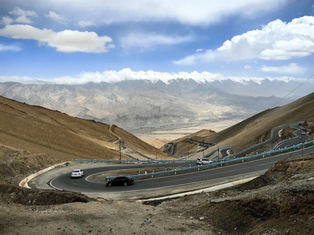
The northern route’s crown is the Duku Highway, a 561 km mountain road named for Dushanzi to Kuqa that climbs from the desert floor to 3,400 meters and back down again in a single day’s drive. I drove it in late June, the first week it opened after the snow melted, and it was the single best day of the entire trip. Snow walls taller than the car lined the high passes. Herds of sheep filled the road. A waterfall poured across the asphalt at one bend and I had to guess where the lane was.
The Duku Highway road trip guide covers the logistics, but the thing to understand for route choice is this: the Duku is only open about five months a year, it is one-way in sections during peak season, and it is closed entirely on most rainy days for fear of rockfall. The north is not just slower. It is conditional.

What the North Gives You That the South Cannot
If the Duku is open, the northern route is the more beautiful drive by a wide margin. You get the grasslands of Bayinbulak, the alpine lake at Narati, the fruit orchards around Korla, and the strange red canyons near Kuqa. You also get variety. The south is desert, desert, and more desert, broken by occasional oasis towns. The north is forest, then meadow, then red rock, then desert, sometimes within a single afternoon.
I have written separately about the Urumqi to Kanas drive for those who want to push the northern loop all the way to the Kazakh border country. For a Kashgar-bound trip, you peel off the northern arc at Kuqa and rejoin the expressway south to Aksu.
The Tarim Loop: A Third Option Nobody Mentions
There is a quieter third choice that blends the two. Drive south to Korla, then take the Tarim Basin loop, a full circuit of both Taklamakan crossing highways, the desert roads that link Korla, Hotan, and Aksu. The Tarim Basin loop guide explains how to do it. It is for travelers with ten days and a real interest in the desert itself, not just the destination. I met a German couple in Hotan who had done it in a raised 4×4 and described it as the loneliest, loveliest week of their lives.
My Honest Recommendation
If you asked me at a Urumqi petrol station which way to go, I would say this. Have a week and it is June through September? Take the north, drive the Duku, and accept that you will arrive in Kashgar tired and happy. Have three days, or is it November? Take the south and save the mountains for a trip that deserves them.
Either way, fuel discipline matters more on these routes than on any European motorway. On the southern expressway I passed stretches of 180 km between stations. On the Duku I once panicked at a quarter tank and learned that the next pump was 90 km away and took only cash. The desert does not care about your plans.
A Few Things I Wish I Had Known
- Weather splits the decision. The Duku closes with no notice. Check the opening status the morning you plan to drive it, not the week before.
- Both routes end at the same place. Kashgar does not care how you arrived. The old town, the Sunday market, and the Pamir road beyond are identical rewards.
- Signal is worse on the north. Download offline maps before leaving Urumqi. The south has better coverage because the expressway is newer.
- Border permits. Neither route requires a permit by itself, but if you plan to continue from Kashgar to Tashkurgan, sort that paperwork in Kashgar before you go.
Pick a route, pack more water than feels reasonable, and go. The road to Kashgar is good whichever way you turn, and the worst mistake is the one I almost made: spending the whole drive undecided and seeing neither.
Fuel, Food, and the Reality of the 200 km Gap
I want to be precise about fuel because it is the one thing that can strand you. On the southern expressway, petrol stations sit roughly every 60 to 100 km, and most take card or mobile pay. On the Duku and the desert side roads, gaps stretch to 150 or 200 km, and some pumps take cash only or close early. I learned to fill at every town and to treat a half tank as empty. Food follows the same pattern: the expressway has service areas with hot meals, while the mountain roads have yurts and roadside grills that appear only in summer. Carry snacks regardless.
Which Route for Which Vehicle
A normal sedan handles the southern expressway without complaint and even manages the Duku in dry summer, though the high passes feel exposed in a low car. An SUV is the better tool for the north, especially if you detour onto the rougher side roads near Kuqa or want clearance for winter slush. A motorbike or bicycle is possible on both but demands more planning for water and weather. The route you choose should follow the vehicle you actually have, not the one you wish you had.
A Sample Six-Day Northern Plan
For a week, I would do: Day 1 Urumqi to Dushanzi; Day 2 the Duku to Kuqa; Day 3 Kuqa caves and red canyons; Day 4 Kuqa to Korla with a Bayinbulak detour if the road is open; Day 5 Korla to Aksu; Day 6 Aksu to Kashgar. That is tight but doable, and it delivers the mountains without the three-day desert slog. Stretch it to nine days and the north becomes a pleasure rather than a push.
The Northern Arc in Detail: Mileage That Matters
If you take the north, the numbers help you plan. Urumqi to Dushanzi is about 250 km and an easy half day. Dushanzi to Kuqa over the Duku is 561 km but plan a full day, because you will stop constantly and the pass is slow. Kuqa to Korla is 280 km, and Korla to Aksu another 330 km on good road. From Aksu the run to Kashgar is 460 km. The total northern arc, with the Duku as its spine, is roughly 1,900 km of driving and wants six to eight days with sightseeing. By contrast the southern expressway is 1,470 km and can be done in three. The extra days on the north buy you mountains, not just miles.
Border Permits and the Southern Route
Neither the north nor the south requires a permit for the drive itself. The permit question only arises if you leave the main route for a restricted county, most importantly Tashkurgan, which sits beyond Kashgar and needs its own paperwork. If your plan stops at Kashgar, you are fine on either route. If it continues to the Pamir, sort the permit in Kashgar before you go, not at the checkpoint. I have written separately on the Tarim Basin loop for those who want to combine both desert highways into one giant circuit.
My Actual Fuel Log
People ask if the remote stretches are safe on fuel. Here is what I logged on the southern run: Urumqi to Korla, filled at Korla; Korla to Kuqa, filled at Kuqa; Kuqa to Aksu, filled at Aksu; Aksu to Kashgar, filled at Kashgar, with a top-up at a midway station near Bachu. The longest gap was Kuqa to Aksu at about 180 km, comfortable in any car. On the Duku I filled in Dushanzi, again in the Bayinbulak area (a small station, cash only), and once more in Kuqa. The lesson: on the expressway you are never far from a pump; on the mountain road, plan the Bayinbulak top-up and do not skip it.
A Note on Checkpoints and Papers
Whichever route you choose, the checkpoint rhythm is the same. Foreign passport holders are stopped at regular police checkpoints, usually every few hours on the expressway and at the entrance to any town. Have your passport and your hotel registration (the little slip hotels must issue you) ready. The process is routine and not hostile; officers are doing their job, and a calm, prepared traveler moves through in a minute. I keep a dedicated zip pocket for documents so I am never fumbling at the window. The checkpoints and fines guide is worth reading before you set off, because the rules about where and when you may stop are stricter than they look.
When I Would Take the South Anyway
For all my love of the north, there are trips where the south is simply right. If you are chasing the Taklamakan specifically, or you are traveling in deep winter when the Duku is buried, or you have limited time and Kashgar is the goal, the southern expressway is the honest choice. It is not the scenic route, but it is the reliable one, and reliability matters more when the weather is working against you. I have driven it twice now and come to appreciate the strange beauty of the empty basin, especially at the blue hour when the desert goes purple.
A Sample Fuel and Time Budget
For planning, here is the southern run in hard numbers: Urumqi to Korla 430 km, Korla to Kuqa 280 km, Kuqa to Aksu 330 km, Aksu to Kashgar 460 km. Total 1,500 km, about 16 hours of driving, done comfortably in three days with overnight stops. Fuel at 2026 prices for a compact SUV ran me roughly 700 RMB end to end. Tolls added about 400 RMB. The north, by contrast, is 1,900 km and at least six days, with fuel nearer 900 RMB and more variable costs. The south is cheaper and faster; the north is slower and worth it. The budget reflects the experience.