
Xinjiang’s Yardang Landforms: How Wind and Water Sculpted the Desert
Xinjiang’s Yardang Landforms: How Wind and Water Sculpted the Desert
On my second morning in Karamay I pointed the rented car northwest and drove 110 km toward the Urho district, chasing a photograph a hostel owner had shown me the night before. He called it the Wind City. I expected a mirage and found, instead, a field of rust-colored stone that looked like a drowned skyline. That was my first yardang, and I spent the next three weeks chasing the next one.
People picture Xinjiang as dunes. The Taklamakan gets the postcards and the scary maps. But in the basins north and south of the Tianshan there is another desert shape entirely, one made not of shifting sand but of rock stripped into long parallel ridges by a wind that never quite stops. The local name for these erosional ridges is yardang, a word that traveled out of the Turpan oasis and is now used by geologists on every continent. I am not a geologist. I am just the traveler who kept pulling over.
Standing Inside the Karamay Wind City
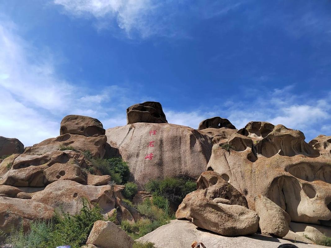
The Urho wind-eroded terrain sits about 100 km from downtown Karamay, reached on a good two-lane road that takes roughly 90 minutes if you stop for the trucks. I paid ¥62 at the gate in early October, when the temperature had settled to a clean 14°C by midday and the tour buses had thinned to a trickle. The site is enormous, maybe 10 km across, and you follow a loop road past formations with names like the Python, the Castle, and the Concert Hall.
What struck me first was the sound. Wind moves through the channels between the ridges and hums, sometimes whistles, and on the day I visited a steady 30 km/h breeze turned the whole basin into a low drone. Our driver, a man from Karamay who had run the loop 400 times, said winter gusts hit 100 km/h and the place earns its ghost reputation honestly. I believed him the moment a gust slammed my door shut while I was standing two meters away.
The ridges run in tidy lines, each a few meters tall, separated by grooves the wind has cut over perhaps hundreds of thousands of years. Stand at the edge and the pattern repeats to the horizon. It reads like a city seen from a hill, which is exactly why people built viewing platforms and gave the rocks nicknames drawn from temples and animals. For a quieter experience, walk 400 meters past the last marked stop and you will have the place almost to yourself, with only the wind for company.
I stayed until the light went flat, then drove back to Karamay for laghman noodles. The next morning I looked at the map and realized the yardang country was bigger than the one paid gate suggested.
How the Ridges Get Carved
The short version is this: take a flat bed of soft rock, add wind that carries sand, and wait. A lot. The Urho basin sits on Mesozoic sandstone and mudstone laid down when this region was a lake bed, long before the climate dried. Once exposed, the rock became a target. Wind here does not blow straight and harmless. It carries abrasive sand grains low to the ground, and those grains sandblast the rock face the way a gardener strips rust with a tool.
Softer layers vanish faster. Harder caps survive. You get the castle-and-tower silhouette that fool’s the eye into seeing ruins. Water did the first rough draft. Brief but violent summer storms still fall on these basins, and flash floods cut the initial gullies that the wind then sharpens into flutes. I watched this logic on a single rock: a rounded top where rain had smoothed it, fluted sides where wind had etched vertical lines like a column. The landform is still under construction and will look different in another thousand years.
Climate makes the difference between a yardang and a dune field. A dune needs sand supply and steady wind but yields to the next storm. A yardang needs dryness, because the moment rain becomes frequent the rock crumbles into soil instead of carving into sculpture. That is why these ridges cluster in Xinjiang’s driest basins, the places where annual rainfall barely reaches 100 mm and the evaporation rate laughs at it.
If you want the science laid out with maps and specimens, Xinjiang’s national parks and reserves cover several of these basins under formal protection, and the visitor centers there do a better job than I can of explaining the stratigraphy. I found the ranger talks at Urho genuinely useful, not the canned slideshow I had feared, and the small museum near the gate had a cross-section model that finally made the layering click for me.
Qitai and the Eastern Basins
Two weeks later I drove east from Urumqi, past Dabancheng and its famous wind corridor, and reached the Qitai area after about 200 km of straight road that slowly climbed out of the city haze. The yardangs here are a different animal. Instead of the tight castle clusters of Urho, Qitai opens into a broader, paler basin where the ridges stretch for kilometers with almost no other color in the frame. I arrived at 5 p.m. and the light did the rest of the work.

The Qitai formations sit near the southern edge of the Gurbantunggut desert system, and the ground between the rocks is cracked clay that grabs a shoe and refuses to let go. I wore light trail runners and regretted it within an hour. A pair of stiff boots would have saved my ankles and my temper. There is no ticket gate here, no loop road, just a dirt track and a weathered sign I could barely read in the fading light. This is the part of Xinjiang that rewards self-sufficiency over itinerary, and it punishes people who arrive thinking the paved world follows them.
I met a herder near the track who pointed me toward a cluster he called the Old Fortress, though he said it in a language I only half caught. He had walked these ridges since childhood and treated them like neighbors, not scenery. That encounter did more for my understanding than any plaque could have.
Why Dusk Changes Everything
Photographers talk about the golden hour, but on yardangs the last 40 minutes of light are something else entirely. The low sun rakes across the ridges and throws the fluting into sharp relief, turning pale stone the color of copper and shadowing the grooves into near black. I shot 300 frames in one evening and kept maybe twelve, and the discards were not bad pictures so much as pictures that missed the moment the light went red.
The stillness helps too. With the wind down and the heat gone, the basin goes quiet in a way that feels older than the road I arrived on. I camped that night a few kilometers off the track, alone, and watched the temperature fall from 18°C to near freezing by 2 a.m. That is normal here in October. Bring a sleeping bag rated to zero and a plan for water, because there is none out there and the nearest shop is back in Qitai town, a 40-minute drive on a road you will not want to drive in the dark.
Getting Out There Without Getting Stuck
The basins are empty, and empty in Xinjiang means you are responsible for your own rescue. Before any of these trips I read up on desert fuel planning, because the distances between working petrol stations out here run 150 to 250 km, and a half tank is a gamble rather than a margin. I topped off the tank in Karamay, Urumqi, and Qitai town every single time, and carried two 10-liter jerry cans on the longer southern drives toward Korla and the Tarim approaches.
Wind is the other hazard, and the subtler one. I got caught in a building dust front near Korla one afternoon when visibility dropped from 20 km to 200 meters in ten minutes, the horizon simply closing like a curtain. The Xinjiang guide to sandstorm driving I had skimmed the week before was the only reason I slowed in time and pulled well off the road rather than pushing on toward a turn I could no longer see. If the sky goes the color of weak coffee, stop the car and wait. The ridges are not going anywhere.
Roadside pull-offs are your friend in a way that is easy to underestimate. The region’s scenic overlooks are marked for a reason, usually placed where the geology reads best and the ground is firm enough to park a normal sedan. I learned to trust those signs and ignore the urge to invent my own turnoff, because the soft shoulder out here means a winch, a long wait, and a story you would rather not tell. The marked viewpoints also tend to have the cell signal the empty track does not.
A word on the car itself. I rented a front-wheel-drive sedan in Urumqi for ¥280 a day and it was fine on the paved loops and the firm clay, but I would not take it down an unmarked track after rain. The locals drive raised pickups for a reason. If you want the remote basins, rent accordingly or join a driver who knows the ground. The money you save on the smaller car you will spend on a tow.
Where Else the Ridges Show Up
Karamay and Qitai are the easy wins, the places with a road and a name, but yardangs scatter across the drier basins in ways the map does not advertise. The southern edge of the Tarim, around the approaches to the Taklamakan, carries wind-eroded rows near the old oasis roads, and you can spot them from the window if you know the shape to look for. South of Turpan, the dried lake beds and the Lop Nur fringe hold weathered ridges that few travelers reach because the permits are real and the distance is longer than it looks.
I did not make it to Lop Nur. I ran out of time and, honestly, nerve, since the route demands fuel caching and a satellite phone rather than a hopeful attitude. A traveler I met in Korla had gone in with a sanctioned group and described yardangs the size of apartment blocks, wind-carved until they looked like the hulls of ships beached on a clay sea. That is the trip I am saving for next.
The Silk Road history helps explain why these places matter beyond the view. The old Silk Road caravanserais, the roadside inns where traders rested and counted their loads, were built precisely because the basins were hostile, and the yardang fields marked both danger and landmark for anyone crossing. Reading about those inns before I drove the southern routes gave the empty landscape a human scale it otherwise lacked. A ridge is geology. A ridge with a caravan story behind it is a place.
Visiting Without Leaving a Scar
Yardang rock is soft, softer than it looks, and I watched a teenager carve initials into a ridge at Urho and felt, unreasonably, betrayed. The grooves that took geologic ages to cut can be damaged by a pocketknife in seconds, and the desert here has no rain to wash the mark away. Stay on the marked loop roads. Walk the firm clay, not the crumbling edges. Pack out every bottle and every wrapper, because wind will tumble your trash halfway to the next province before you reach the gate, and someone else will photograph your litter as if it were part of the view.
Drone flying is tempting and, in places, restricted. I asked at the Urho ticket office and was told no within the fenced site, yes outside it with the right permit, and the answer changed again when I asked in Qitai, where the county had different rules entirely. Check locally rather than assuming, because the fine for a wrong guess is steep and the rangers out here are not joking. The same goes for camping. The basins are not a free-for-all, and the national park boundaries exist for a reason that becomes obvious the first time you see a fragile crust break under a boot.
A ranger in Qitai politely but firmly moved me 300 meters off a patch of biological soil crust, the black cracked skin that holds the desert together, and he was right to do it. I had been about to pitch a tent there because it looked flat. That crust takes decades to recover and I would have killed it for one comfortable night. Walk the hard lines between the ridges. Leave the skin alone.
Practical Notes Before You Go
The best months are September through early November, when the heat has gone and the light sits low for the long shadows that make yardangs photograph well. June and July are brutal, with basin temperatures above 40°C and a glare that flattens every photograph into a white-out. I went in October and would do it again without hesitation. Spring works too, though the winds in March and April are the strongest of the year and the dust can close a road for a day.
Carry 4 liters of water per person per day even in October, when the air lies about how much fluid you are losing. Tell someone your route and your return time, and then actually stick to it. Download offline maps before you leave the highway, because signal dies the moment you turn off the pavement and a dead phone in a clay basin is a serious problem rather than an inconvenience. A paper map of the region is not nostalgia out here. It is a backup.
Bring food you can eat cold, a headlamp, a first-aid kit, and more sunblock than feels reasonable. The UV on an open ridge at 1,000 meters reflects off pale stone and burns the backs of your knees before you notice. I learned this the hard way and spent an evening in Karamay looking like a cooked crab while the locals found it hilarious.
I left Xinjiang with more questions than the trip answered, which is the mark of a good landscape and the reason I trust it. The yardangs will keep eroding whether I return or not, indifferent to the cameras and the nicknames we hang on them. But I will return, probably in March, when the winds are strongest and the ridges sing the loudest, and this time I will bring the pickup, the satellite phone, and a permit for the south. Until then the photographs will have to stand in for the drone.